

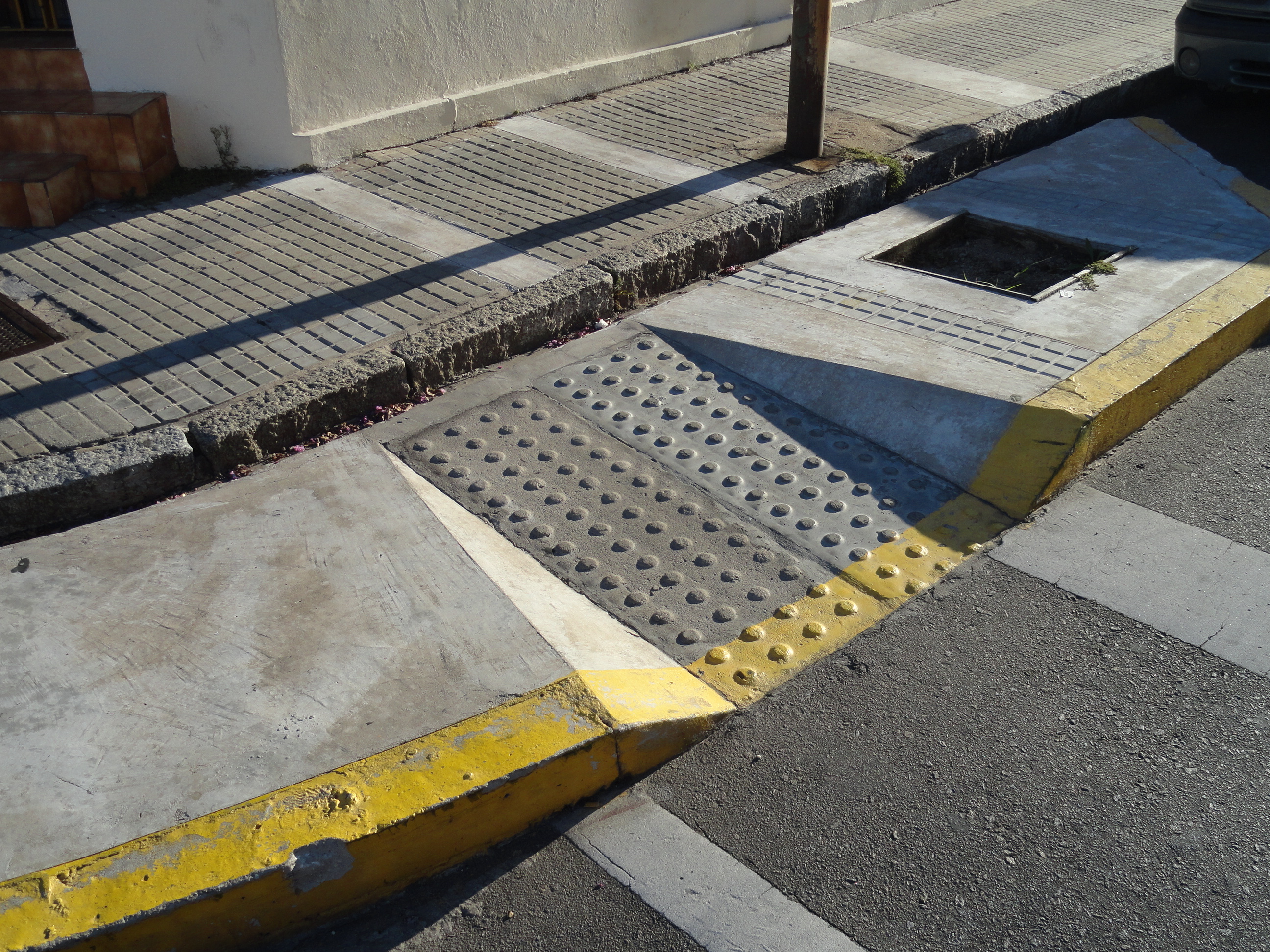
There is a street corner in Maldonado, Uruguay, where a sidewalk slopes dutifully towards the road and then meets a drainage channel. In a photograph of the crossing, the ramp seems to have performed its assigned task: it points towards the street, announces a concession to access and satisfies the eye. The gutter interrupts the journey at precisely the place where smooth passage matters. It is a small piece of infrastructure, but a large idea about cities is caught inside it.
A map would have little to say about that gutter. It might show a connected road network, a nearby pharmacy, a grocery shop five minutes away. It could colour the surrounding streets green and call the neighbourhood convenient. Yet convenience is not a property of pavement in the abstract. It emerges in the encounter between a particular person and a particular place, on a particular day. Sometimes that encounter depends on a matter of centimetres.
The 15-minute city, an urban-planning idea built around access to daily necessities within a short walk or cycle ride, has given cities something they often lack: an idea that ordinary people can picture and politicians can explain. Its appeal rests on groceries, parks, schools and care close to home. But the 15-minute city’s accessibility problem is not always one of distance. It is the gap between what a map counts as reachable and what a resident can actually use. It has also given cities a dangerously appealing unit of success. Fifteen minutes sounds exact, humane and egalitarian. But whose minutes are being counted? And how much of a human life can any travel-time map really contain?
What the 15-Minute City Promises
The 15-minute city, popularised by the Franco-Colombian urbanist Carlos Moreno, is a model of urban planning in which daily needs such as work, food, healthcare, education and recreation are located within roughly a 15-minute walk or cycle ride of home. It is a principle of walkable neighbourhoods, not a legal boundary around where people can travel. Its appeal lies in reversing a familiar assumption: that progress consists of travelling ever faster between places deliberately built far apart. A child should not need a chauffeured journey to reach a playground. A household should not have to plan an expedition for basic food. The hours surrendered to commuting could become hours available for living.
This is more than a marketing slogan. The proximity ideal offers a way to argue for mixed-use neighbourhoods, local services and streets on which people, rather than automobiles, are welcome. It can reduce dependence on cars and help make ordinary errands less burdensome. Cities promoting the model place social inclusion and better access at its centre. It would be unserious to attack the vision because some attempts to measure it fall short.
The difficulty begins when a moral aspiration becomes an exercise in counting. A circle around an address is easy to understand. A more sophisticated network map is better: it traces paths along streets and accounts for travel time. Neither is useless. But when the resulting shape stands in for the experience of everyone who lives within it, a useful planning instrument becomes a claim the evidence may not support. The same neighbourhood can be efficient on paper and exhausting in practice.
Why Fifteen Minutes Is Not Equal Access
Researchers at the University of Helsinki tested the fiction of a single walking speed against the complicated reality of older people’s journeys. Elias Willberg, Christoph Fink and Tuuli Toivonen measured walking speeds in dry and winter conditions, then combined them with where people lived and when shops were open. Their 2023 study did not ask merely how far a grocery store was from someone’s home. It asked what it meant to reach that store under changing conditions.
The result was startling. In the study’s baseline model, 93% of older residents had a grocery store within a 15-minute walk. In the most restrictive combination of walking and time-of-day conditions, that share fell to 34%. These are modelled scenarios, not a census of people literally turned away from supermarkets. Their significance is that the apparently straightforward question, “Is food within fifteen minutes?”, changes its answer when the assumptions change. Shop hours mattered even more than some differences in walking speed when examined separately.
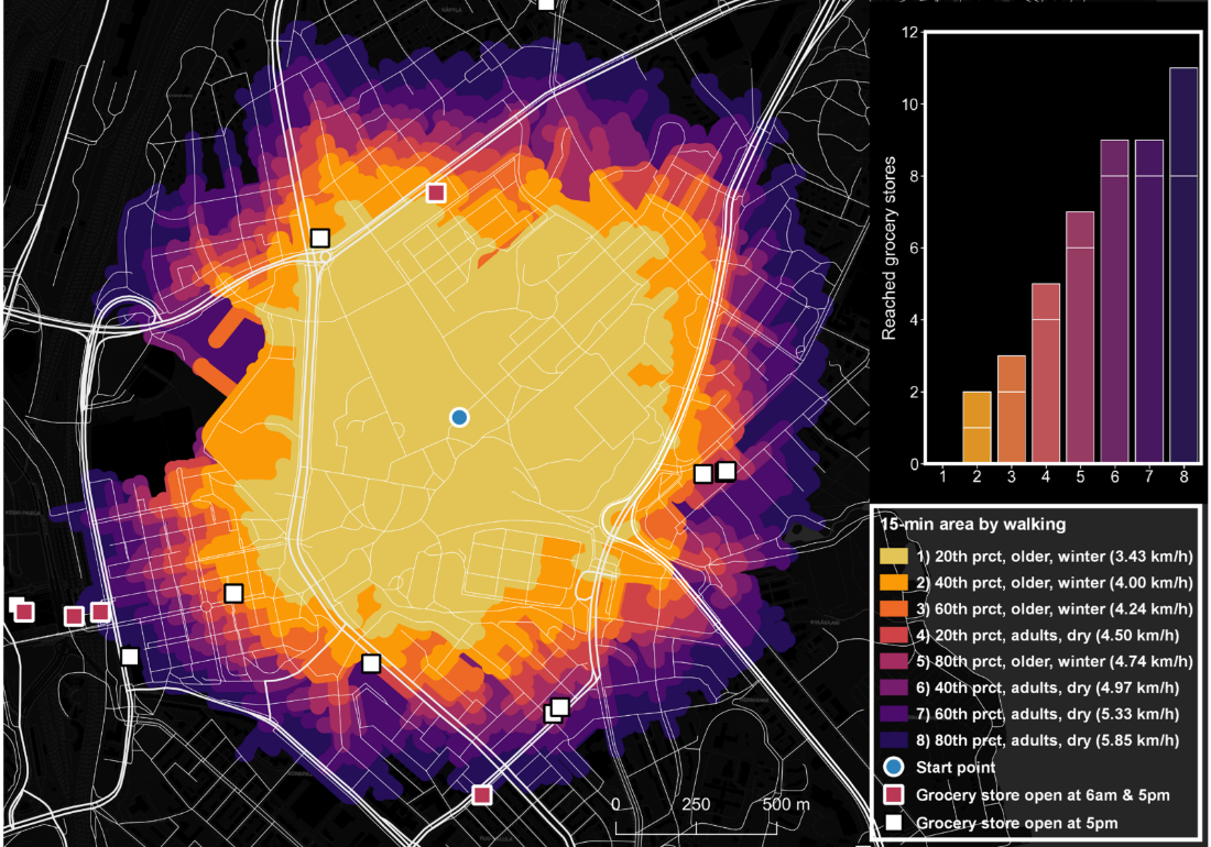
The image has a peculiar force. One address, several possible worlds. In one, the errand is uncomplicated. In another, walking conditions and the shop’s schedule make the same errand unrealistic. The conventional map is not necessarily wrong: it is answering a narrower question than readers may assume. It can tell you how long a route takes under its assumptions. It cannot, by itself, tell you how that journey will feel, whether it can be completed, or whether the shop is worth reaching.
And those omissions are not limited to age. A parent pushing a stroller, someone navigating with a white cane, a wheelchair user facing a steep gradient, a person with chronic pain or a shopper returning with heavy bags may experience the same street differently. None of these groups has one fixed speed or a single set of needs. Disability, in particular, should not be reduced to moving slowly. For many people the critical variable is not speed but whether an apparently connected journey is actually traversable.
A 2026 Hong Kong study of older adults’ walking accessibility strengthens that distinction. Using a three-dimensional pedestrian network sensitive to gradient and barriers, the researchers found that a uniform 15-minute benchmark can underestimate accessibility gaps among older residents. Their age-sensitive approach examined shorter thresholds for different needs. One clock cannot reveal the same opportunities to everyone, even before service quality or cost enters the picture.
The city is not one journey repeated by different people. It is different journeys occupying the same streets.
The Last Millimetre of the City
Ronald Buliung, a geographer at the University of Toronto Mississauga, has a more exacting name for this discrepancy. Writing in Disability & Society, he describes “last millimeter problems”: small barriers, including the gap between a train and a platform, that can make an otherwise navigable city impassable. His intervention is a hopeful critique of the 15-minute concept rather than an argument for abandoning proximity. The distance to a destination matters, but the final transition can govern the whole journey.
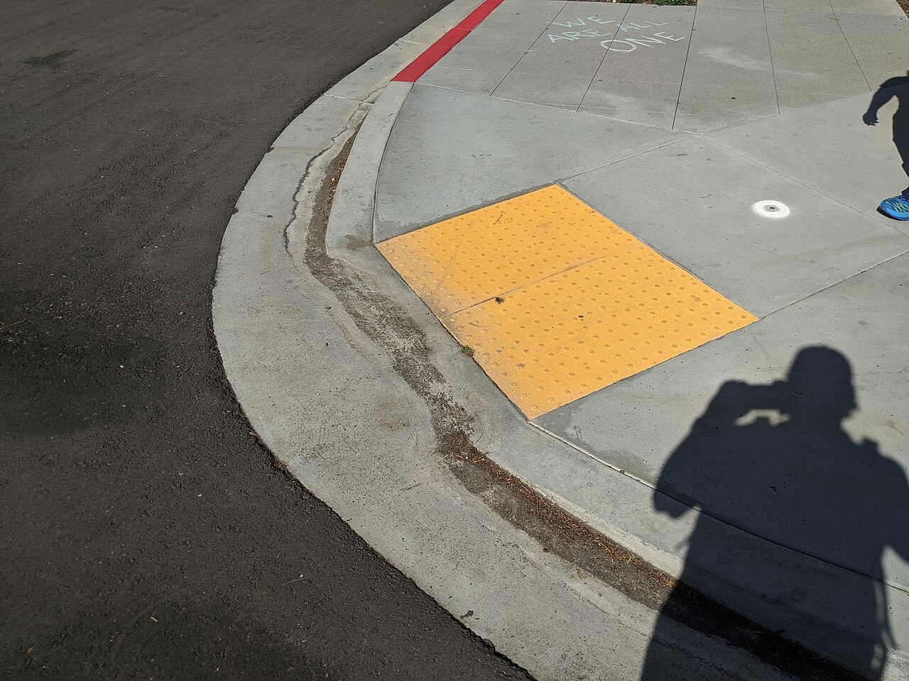
Consider the two curb ramps pictured below. One offers a relatively continuous transition between sidewalk and road; the other meets a drainage opening. These photographs do not constitute a controlled assessment of either city’s accessibility. Their value is more immediate: they show why an account of urban access that ends at the edge of a street network may be missing the place where a journey breaks.
The phrase “walkable city” itself deserves scrutiny. Walking has become the default verb of contemporary urban virtue. Yet even where sidewalks are excellent, urban freedom may depend on wheelchair access, a reliable bus, a safe place to rest, a lift that functions, an audible crossing signal, a comfortable gradient, or information that can be understood without sight. A city that congratulates itself on walkability while treating these needs as exceptions has mistaken one mode of movement for the definition of public life.
That distinction between walkability and accessibility has been measured, not merely argued. Researchers modelling Barcelona’s sidewalk networks found that even a pedestrian-friendly city can lose substantial access to social and health services when moderate physical constraints are introduced. In a 2026 assessment of Porto, surveyors documented 80 crossings in the historic centre, 18 without curb ramps. The studies illuminate distinct ways a city can look walkable while still presenting major barriers to wheelchair users and older pedestrians.
The World Health Organization estimates that 1.3 billion people, around 16% of the world’s population, experience significant disability. But an equitable city is not designed by reducing that vast, heterogeneous population to a special checklist. Its most consequential knowledge often comes from disabled people themselves: which journeys they avoid, what detours have become routine, when assistance must be requested and where an apparently accessible service breaks down. The distinction is between being permitted to move and being able to do so with ordinary independence.
The inaccessible city rarely announces itself with a single monumental failure. More often it accumulates the small taxes of inconvenience: the crossing one cannot trust, the shop entered through a back door, the broken lift that turns a spontaneous outing into a logistical exercise. A map of what is nearby can fail to record precisely the effort that makes “nearby” feel far away.
Proximity Does Not Produce a Life
There is a second problem, subtler than a broken curb. Suppose the streets are genuinely comfortable, the crossings excellent and the shops open. Would a city of nearby destinations necessarily produce a life lived nearby? Not according to a revealing 2025 study of Barcelona. Using detailed accessibility data alongside a survey of travel behaviour, the researchers found that 95% of their respondents lived where an everyday set of amenities was theoretically reachable within a 15-minute walk. Yet just 26% made all their non-commuting trips using predominantly active modes within that fifteen-minute area.
The difference is too large to dismiss as poor mapping, but it would be equally misleading to call it evidence that Barcelona had failed. People travel beyond their neighbourhoods for reasons that are not errors in urban design. Their friends may live elsewhere. A particular doctor, library, workplace, cultural institution or place of worship may be worth the extra distance. The nearest grocery shop is not always the shop one can afford, trusts, likes or finds suitable. A city’s promise of convenience does not erase our right to preference, attachment and curiosity.
This is the part of the discussion that statistics can make strangely hard to see. Counting destinations treats services as interchangeable points. One park is not necessarily as useful as another. A clinic with no appropriate specialist does not meet the need simply by appearing within a quarter-hour catchment. A school place, a public restroom or a bench has qualities that do not fit neatly into a proximity score. The planning critic Kostas Mouratidis has identified the tendency to count destinations without considering their sufficiency, to aggregate unlike facilities and to neglect public transport as among the pitfalls in applying the 15-minute framework.
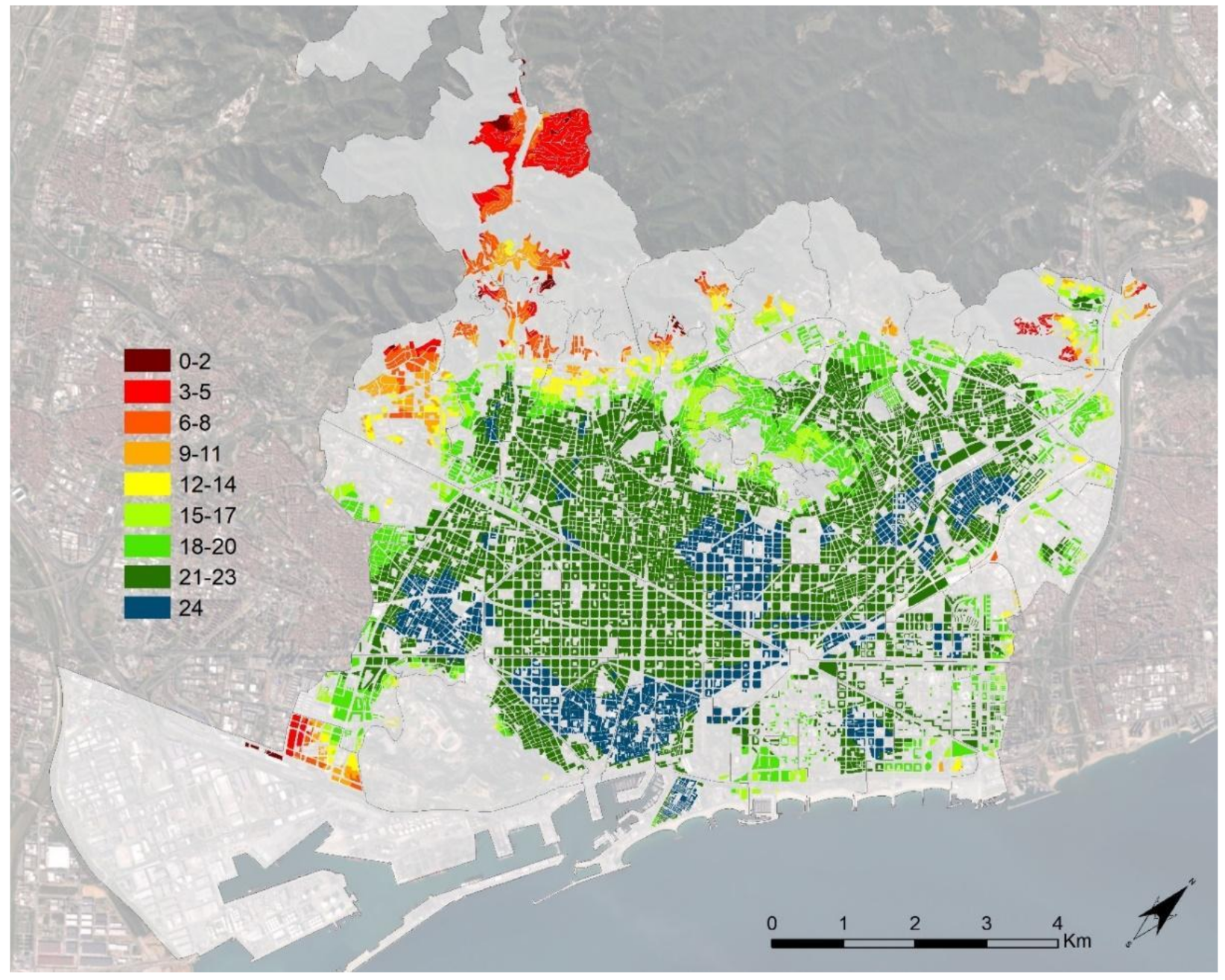
Barcelona’s proximity maps are impressive and useful. They reveal geographical variation in everyday services. But the difference between a destination’s presence and a resident’s choice to use it is not a minor statistical inconvenience. It is the difference between an inventory of the city and an account of living there. Proximity enlarges the set of possible choices. It cannot, and should not, dictate the choices themselves.
Who Can Afford the Good City?
Once accessibility is treated as more than distance, an uncomfortable economic question appears. What happens when a neighbourhood becomes convenient, attractive and safe, but the people who needed those improvements can no longer afford to remain? The politics of proximity are also the politics of housing. A bus stop can be close and still unaffordable to use. A flourishing high street can contain little that a low-income resident can buy. A beautiful place can become a benefit advertised to its future inhabitants rather than delivered to its current ones.
A 2024 study of Gothenburg, Sweden, using registry data from 2011 to 2017, found an association between gentrification and improved local accessibility in certain low-income neighbourhoods. The authors urged attention to the interaction between neighbourhood improvement and socio-spatial polarisation. That association is not proof that 15-minute-city policies caused displacement. It is a warning that describing accessibility as an uncomplicated public good can conceal a question about who eventually enjoys it.
The wider scholarship has begun to treat this as a question of justice, not just geography. A 2026 review of 102 academic publications called for more attention to representative participation, gentrification and displacement, and the social dimensions of measurement. A separate 2026 justice-oriented framework argued that accessibility must include affordability, quality and responsiveness to local needs. These concerns resist the simplicity of the coloured catchment map because they cannot be solved with distance alone.
There is a strange irony here. The 15-minute city began as a promise to restore time to ordinary people. If that promise becomes primarily a measure of what services property owners can advertise, the metric may survive while its moral purpose is hollowed out. A neighbourhood is not more accessible to a displaced resident because their former address now scores better. The same caution applies to improving a district without making public transport connections to the wider city: local convenience should not become a substitute for metropolitan opportunity.
The Small Fiction Inside Every Dashboard
Product designers ought to recognise this predicament. We are accustomed to a deceptively tidy form of progress: fewer clicks, shorter funnels, cleaner journeys, faster completion. Those measures are useful, until the product starts behaving as though it knows what completion means for every person. A form may take four steps if you can see it, read the labels and use a mouse. For somebody using a screen reader, it may contain a dead end. The published flow has not changed; the lived experience has.
Urban accessibility maps and digital user journeys share an intellectual habit: they render behaviour legible by simplifying it. Simplification is indispensable. Without it, we could not plan a street or design a service. But a simplified model becomes dangerous when its omissions are silently converted into truths. The short route is treated as the usable route; the visible button as the operable one; the presence of a local facility as a completed human need.
That is why DW has questioned the conflation of workarounds with access in AI agents and web accessibility, and the substitution of simulated responses for lived evidence in synthetic user research. Technology may become better at predicting what an average person can do while remaining strangely uncurious about the person for whom the prediction fails. As our exploration of user-centred design’s political history argued, the deeper purpose of participation is not simply to improve a model’s accuracy. It is to give affected people influence over what gets designed and why.
An algorithm can tell a planner that a neighbourhood has three clinics within ten minutes. It cannot know from that count alone whether a person can obtain an appointment, navigate the building, afford the visit or receive the care they need. A team can calculate conversion without learning who gave up before they ever appeared in the funnel. In both cases, absence has a habit of looking like success to the system that failed to record it.
What an Accessible 15-Minute City Needs
The better response is neither to abandon quantification nor to surrender to endless complexity. It is to ask more exact questions and resist the urge to compress their answers into one flattering number. An inclusive 15-minute city needs more than nearby destinations: continuous step-free routes, usable crossings, comfortable gradients, rest stops, accessible public transport, dependable opening hours and services people can afford. These are the conditions that turn walkability into meaningful access. Cities can continue mapping travel times while measuring those conditions separately and reporting how they vary across neighbourhoods and mobility needs. They can distinguish a nearby opportunity from an opportunity that can actually be used.
A 2026 Vancouver study shows what that shift can reveal. Using a multidimensional index that included service access, infrastructure and housing affordability, its authors found that 74.5% of residents were within the model’s acceptable walking-time thresholds to essential amenities, whereas 37.9% lived in areas classified as accessible by the broader index under the study’s assumptions. Those figures answer different questions and should not be subtracted to produce a count of excluded people. Their value is to show how quickly a city’s apparent performance changes when the definition of accessibility becomes less convenient.
And even the cleverest index remains incomplete without the residents whose lives it describes. In a 2025 community-informed study of Surrey, British Columbia, participants identified amenities missing from conventional counts, including places of worship, and emphasised safety, terrain and supportive street design. These were not simply extra data fields. They were evidence that experts and residents do not always agree on what a useful city contains.
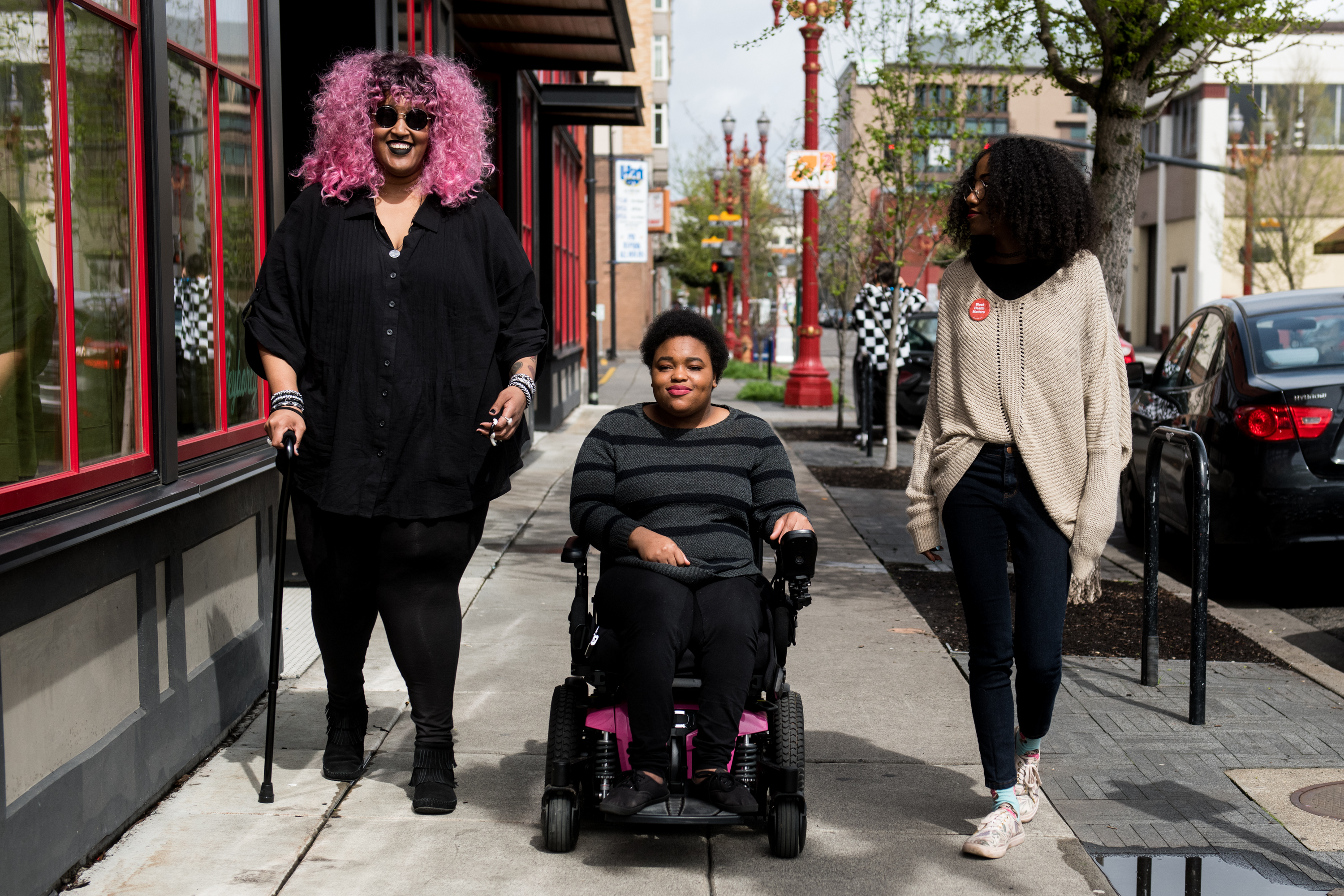
There is a difference between consulting people about a predetermined plan and allowing them to alter the questions that the plan asks. If a person says the nearest park is inaccessible, the response is not to reassure them that the park is five minutes away. If residents say their social and cultural life cannot be found in the official set of amenities, the answer is not to insist they have enough amenities. Listening matters most when it threatens the elegance of the metric.
The obvious temptation is to build an ever more elaborate dashboard, one that calculates walking ability, weather, income, gradient and desire until the city appears finally and perfectly measurable. It would be a useful instrument, and still not a substitute for political decisions about which barriers to remove, whose testimony to trust and which services must remain public or affordable. Data can locate a problem. It cannot decide on its own what a just solution requires.
A city that is easy to reach on paper is not necessarily a city people are free to inhabit.
The Right to a Larger Life
The most persuasive case for the 15-minute city is not that it will confine life within fifteen minutes. It is that everyday necessities need not consume so much of it. Good local access can make spontaneous visits easier, make care less exhausting and release time for journeys people actively choose. Its measure of success should not be the proportion of residents who remain within a circle, but the freedom those residents acquire because daily life has become less difficult.
That freedom has at least two dimensions. There is the freedom to reach nearby places without a punishing negotiation with the built environment, and the freedom to go farther when the people, care, work or pleasures we value happen to be elsewhere. A generous city should make both possible. It should not require residents to fit a model’s default body, pace, income or geography before granting them the benefits of its design.
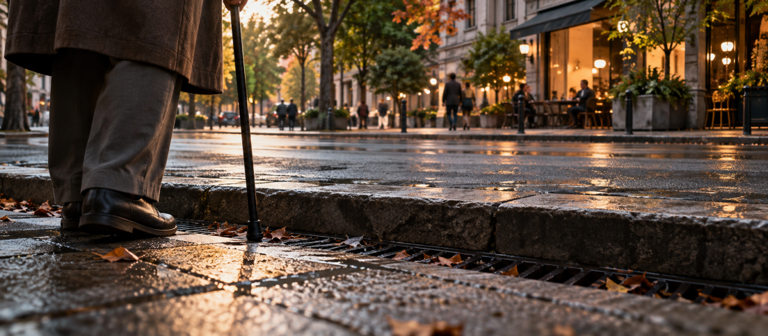
Return, finally, to the gutter at the end of that ramp. It is a detail too small to register in a citywide percentage and large enough to determine whether a journey continues. The lesson is not that the fifteen-minute ideal is false. It is that fifteen minutes can never be the whole story. A city becomes accessible not when the map draws a neat boundary around what is near, but when the person at the edge of the pavement can go on.
Frequently Asked Questions
What is a 15-minute city?
A 15-minute city is an urban-planning concept that aims to place most everyday necessities, including food, education, healthcare and recreation, within about a 15-minute walk or cycle ride of home. The goal is to make nearby services easier to reach, not to restrict how far residents may travel.
What are the main disadvantages or criticisms of the 15-minute city?
Criticisms include one-size-fits-all walking times, barriers facing some disabled and older residents, differences in service quality and affordability, weak connections to public transport, and the risk of gentrification or displacement. Proximity is useful, but incomplete as a measure of opportunity.
Are 15-minute cities accessible to disabled people?
They can be, but short distances do not guarantee accessible journeys. Sidewalk continuity, curb ramps, safe crossings, step-free entrances, accessible transit, sensory conditions and usable destinations matter. Inclusive planning requires testing with disabled residents, not only theoretical walking-speed maps.
What is the difference between walkability and accessibility?
Walkability describes how well streets support movement on foot. Accessibility asks whether people with different abilities and resources can reach, enter and use the places and services they need. A walkable neighbourhood may still contain inaccessible crossings, steep slopes or unaffordable services.
How can planners measure accessibility in a 15-minute city?
Travel-time maps can be combined with data on step-free pedestrian routes, gradients, transit access, opening hours, affordability, service quality and different mobility scenarios. Local route audits and participatory research uncover barriers that geographic models alone can miss.
Does the 15-minute city mean people cannot travel beyond their neighbourhood?
No. The idea is to make everyday necessities easier to reach locally. It does not propose legally confining people to a 15-minute area. Residents should remain able to travel across the city and beyond, using accessible streets and connected public transport.








When does a city become genuinely accessible: when services are nearby, or when people can actually use them? We’ve explored research from Helsinki, Barcelona and Vancouver, alongside the human barriers that maps routinely miss.